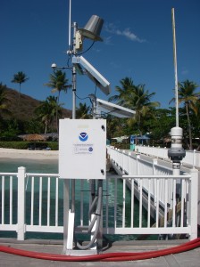
 JOA Surveys, LLC (JOA) has a detailed knowledge of tidal datum determination methods for diverse tidal regimes. The tidal datums determined are required to correct hydrographic survey soundings to MLLW for nautical charts, and they may be used to define coastal boundaries between tideland and upland owners.
Building upon specialized training from the NOAA Center for Operational Oceanographic Products and Services (CO-OPS), JOA has developed extensive software toolkits in Matlab and Python for processing water level data, tabulating high and low tides and computing tidal datums by the method of Tide by Tide Simultaneous Comparisons (TBYT) or Monthly Means Simultaneous Comparisons (MMSC). JOA has adapted the NOAA algortihms to handle unorthodox data acquisition time periods to allow for more flexibility in planning fieldwork.
JOA has also computed chart datum for locations outside of the United States based on Lowest Astronomic Tide (LAT), using least squares harmonic analysis to derive the harmonic constituents from which LAT can be determined.
